While on our way to Thing 1’s graduation from Flagler College in St. Augustine, we made a stop at Ocmulgee Mounds National Historic Park in Macon. We had taken our daughters to the historic park about ten years ago, but I wanted to spend more time and visit the museum.
Plans are underway to make Ocmulgee Mounds the first National Park in Georgia. With the recent purchase of over 800 acres in Twiggs County, the creation of Ocmulgee National Park is a possibility in the near future.
Ocmulgee Mounds
With the LSU Campus Mounds in Baton Rouge as my reference point, I thought most mounds were just small, rounded hills. Imagine my surprise when we visited Ocmulgee Mounds with mounds reaching as tall as 55 feet!
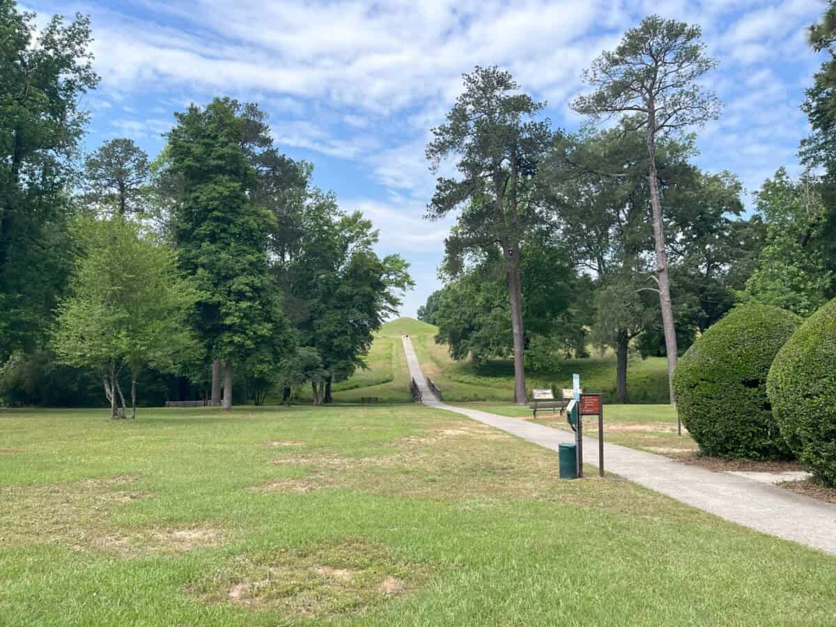
Following significant archaeological excavations by the Works Progress Administration (WPA), the government established Ocmulgee Mounds National Monument in 1936. The Civilian Conservation Corps (CCC) established a camp and constructed the museum and visitor center, trails, bridges, and paved roads. In 2019, Ocmulgee became Ocmulgee Mounds National Historic Park. The grounds include seven mounds, eight miles of walking trails, and a museum.
Ocmulgee Mounds History and Museum
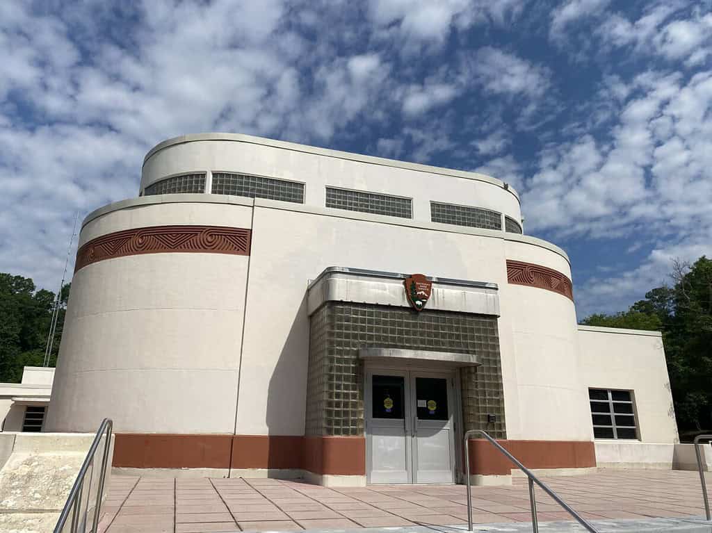
We went inside the Art Deco-style visitor center. Although construction began in 1938, World War II halted the actual completion of the building until 1951. The ranger pointed out the museum behind him, which contains over 2,000 prehistoric artifacts.
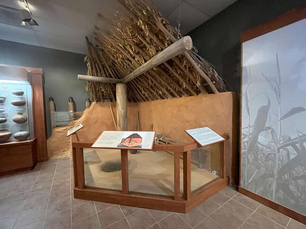
The museum highlights the various groups of Indians who inhabited the Macon Plateau area through artifacts. Experts believe that the first inhabitants arrived during the Ice Age or Paleo-Indian period, approximately 17,000 years ago. Other groups inhabited this area during the Archaic and Woodland periods. Around 900 AD, the Mississippian Indians arrived, building mounds for ceremonies, platforms, and burial remains. These people planted their own food (squash, corn, and beans), built complex villages, elected chiefs, and stayed on the Macon Plateau until 1200 AD. They left this particular area for unknown reasons, but established the town of Lamar, three miles south, around 1350. Although part of the NPS property, Lamar is not open to the public.
By the time Europeans arrived in North America, the Muskogee (Creek) Indians had already established the “Okulgi” village on the site along the Ochese Creek (now called the Ocmulgee River). The Muscogee typically set up villages near rivers and creeks, earning the nickname “Creek” by the British.
We also learned that the Mississippians created the mounds by piling buckets of dirt over a number of years, even centuries. This is evidenced by mounds exhibiting at least seven different sediment layers. The Temple Mound served as a platform for the Chief’s house, while houses for other tribe leaders were situated on the Lesser Temple Mound. Both mounds offer residents a view of the town below.
Other exhibits in the museum included pottery found on the site, a diorama depicting the Green Corn Ceremony, and information about Moore’s Raid, in which the British joined forces with the Ocmulgee Muscogee Indians to destroy Spanish Florida villages in 1703. However, the Muscogee turned against the British during the Yamasee War in 1715. At that point, the Muscogee left Ocmulgee to settle closer to the Chattahoochee River.
Earth Lodge
When walking outside the visitor center, we came to the Earth Lodge. Had it not been for the timber-framed door, we would have walked right by it as it appeared to blend into the landscape.
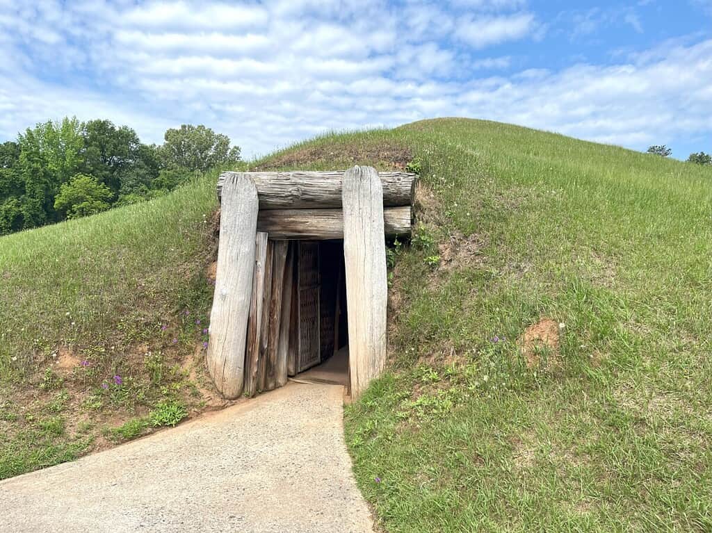
Ducking our heads, we walked through the entrance into the ceremonial chamber. Inside it was dark, but our eyes soon adjusted to a cavernous space held up by timbers. Up until this point, I thought mounds were only used for burial grounds.
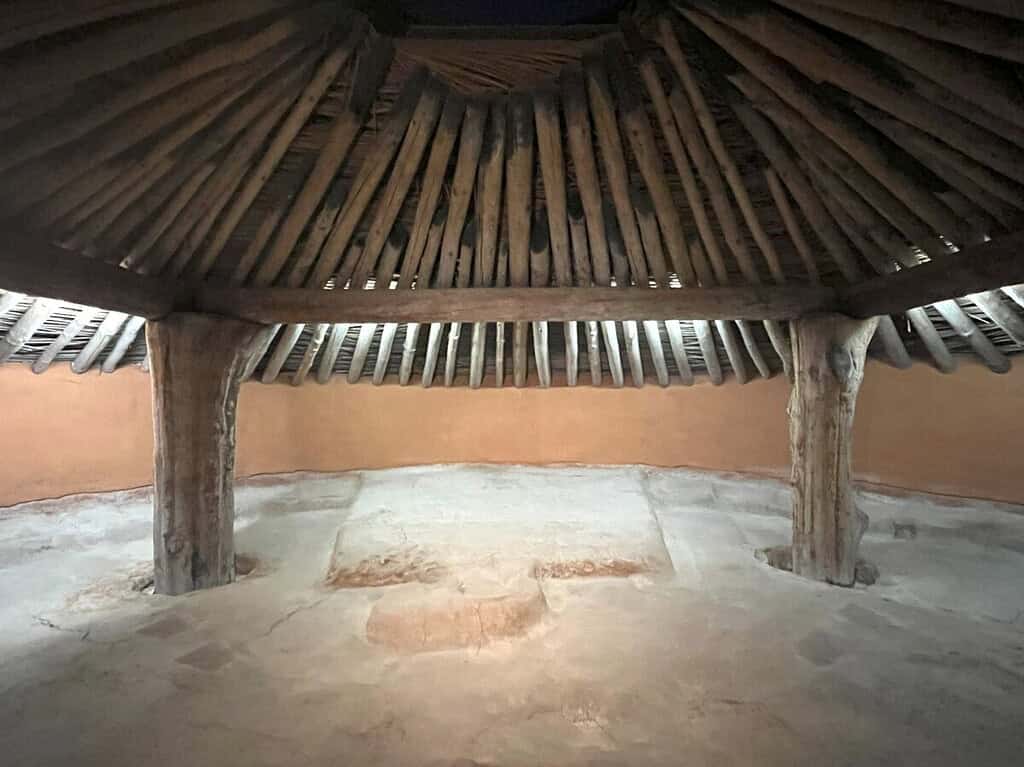
The Earth Lodge held ceremonial events and tribal council meetings with over 40 members. Archaeologists discovered the space in 1934 and later carbon-dated the original collapsed timbers to 1015 AD. It is the oldest Ceremonial Lodge to date. The CCC rebuilt the earth lodge, retaining the original clay floor with its bird-shaped design and bench seating around the circular walls. You can see excavation pictures from the 1930s here.
Great Temple Mound Complex
We continued walking for about a half-mile to the Temple Mound Complex, which features the two largest mounds – The Great Temple Mound and the Lower Temple Mound. However, before that, we crossed a wooden bridge over the railroad tracks (more about that later) and passed the site of an English Trading Post founded in 1690.
Although the English Trading Post appears to be a flat expanse of grass today, archaeologists know this was the exact location of the store and the five-sided stockade wall. The Muscogee often traded deer skins for guns, clothing, hoes, and hatchets. However, the Muscogee burned down the British Trading Post during the Yamasee War in 1715.
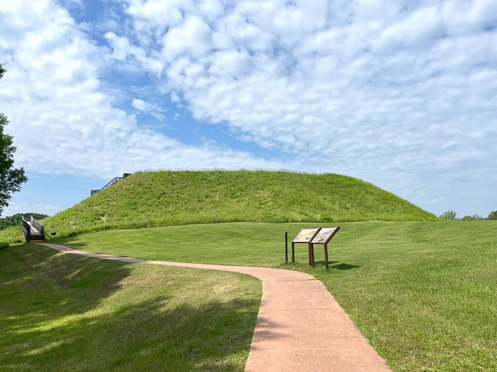
The Great Temple Mound appeared in the distance. Until we got up closer to the flat-topped, pyramid-shaped mound, I didn’t appreciate its size. The base roughly measures 300 feet by 270 feet. A wooden boardwalk and a series of steps led us to the top.
At the top, we could see the skyline of Macon and the Ocmulgee River. The flat area expanded so far in all directions that it felt more like a soccer field. The structure felt solid beneath me, and I could envision the Indian buildings up here. The Chief would definitely have had a great view and could see the goings on of all the villagers.

Taking the stairs back down, I appreciated the work that went into building the mounds. Apparently, 10 million baskets, each weighing about 60 pounds, went into creating the mound. A large plaza area near the base would have hosted gatherings and religious ceremonies.
Before leaving, we quickly headed to the Funeral Mound. Apparently, the mound stood as high as the Great Temple Mound at one point. Not everyone was buried here, just tribe leaders and prominent members.
Railroads in the Park
It’s amazing the mounds at Ocmulgee were still in existence to be discovered by archaeologists. In 1843, a railroad connecting Macon to Savannah, cut right through the park, causing significant damage to Lower Temple Mound. Two Civil War battles also took place in the park in 1864: the Battle of Dunlap Hill and the Battle of Walnut Creek. Visitors can see some of the original earthworks today.

After the war, the railroad made another track, causing damage to the Funeral Mound (lowering it from 50 feet to 20 feet tall). Workers found skeletons and artifacts on the site. The new railroad line caused the creation of the railroad overpass, now listed on the National Register of Historic Places, to accommodate horse and buggy access to the nearby Dunlap House. At the time of construction, most railroad bridges were made out of stone. However, this bridge is unique because it was constructed from brick.
Conclusion
So what happened to the Muskogee Indians? When the invention of the cotton gin made land for growing cotton more valuable than land for growing corn, the United States began pushing the natives out of Georgia. For about two decades, the tribe held onto the small patch of sacred land at Ocmulgee (then known as Ocmulgee Fields) after the First Treaty of Washington was signed in 1805. Unfortunately, in the 1830s, the United States forced their removal to Oklahoma (the Trail of Tears). Today, the Muscogee (Creek) Nation is the fourth-largest tribe. If Ocmulgee becomes a National Park, the Muscogee would co-manage it with the US government.
There is no admission fee to Ocmulgee Mounds. The visit, including time in the museum, lasts about an hour, making it a great stop if you find yourself in the Macon area. For more information, click the site’s website here.